Managing livestock across hundreds or thousands of acres of Florida pasture has always been a time-intensive, physically demanding job. Between checking fence lines, monitoring herd health, assessing forage quality, and tracking water levels, ranchers can spend entire days in the saddle or behind the wheel of a truck — and still miss problems until they become expensive.
Agricultural drones are giving Florida cattle ranchers a practical new tool that saves time, reduces stress on animals, and catches issues before they escalate. Here’s how it works in the real world.
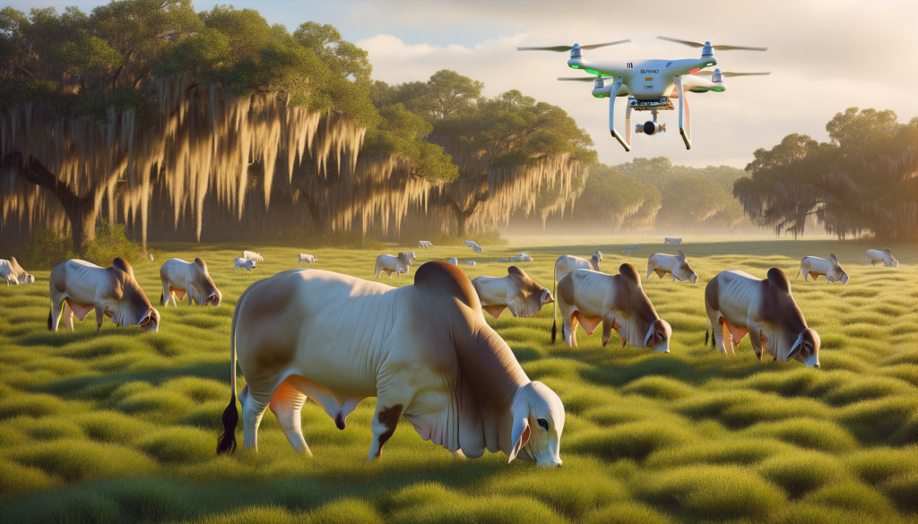
Daily Herd Monitoring Without the Disruption
One of the biggest advantages of drone-based livestock monitoring is what it doesn’t do: it doesn’t spook the herd. Traditional checks — whether on horseback, ATV, or truck — create noise, movement, and disruption that can stress cattle, particularly during calving season or when animals are already dealing with Florida’s summer heat.
A drone flying at 150 to 200 feet can cover a pasture in minutes, providing real-time video of herd distribution, behavior, and condition. Ranchers can identify animals that are isolated, limping, or showing signs of illness without ever entering the pasture. For operations running Brahman, Brangus, or other heat-adapted breeds common in Florida, this low-stress approach lines up with good animal husbandry.
Fence Line and Infrastructure Inspection
Florida pastures take a beating. Storms, flooding, fallen trees, wild hogs, and simple wear all damage fencing — and a single gap can mean lost cattle, liability issues, or mixing herds that need to stay separated.
Drone flights along fence lines replace hours of driving with a 20-minute aerial survey. High-resolution cameras pick up broken posts, sagging wire, washed-out sections, and gate problems. The imagery is geotagged, so repair crews know exactly where to go. For ranches with miles of perimeter fence across flat, wet terrain that’s hard to access by vehicle, this alone can justify the cost of drone services.
Forage Assessment and Grazing Rotation
Good grazing management depends on knowing what your pastures actually look like — not what you assume based on the last time you drove through. Drones equipped with multispectral sensors measure vegetation health across entire pastures in a single flight, producing maps that show:
- Which paddocks have the strongest forage growth
- Where overgrazing is thinning ground cover
- Bare spots that need reseeding
- Weed encroachment, particularly from tropical soda apple, cogongrass, or smutgrass
This data takes the guesswork out of rotational grazing decisions. Instead of moving cattle on a fixed schedule, ranchers can rotate based on actual forage conditions — keeping pastures healthier and carrying capacity higher over time.
Water Source Monitoring
Florida ranches rely on a mix of ponds, troughs, ditches, and natural water features to keep livestock hydrated. During dry spells, water levels can drop fast. During wet season, flooding can contaminate sources or make them inaccessible.
Regular drone flights provide visual checks on every water source across the property without requiring someone to physically visit each one. Thermal imaging can even detect pump failures or blocked lines that reduce water flow to remote troughs — problems that might go unnoticed for days during a busy season.
Head Counts and Missing Animal Location
Counting cattle across large, wooded Florida pastures — especially those with palmetto thickets, oak hammocks, and swampy lowlands — is notoriously difficult from the ground. Animals hide in shade, wander into tree lines, or settle into low spots that aren’t visible from roads or trails.
Drones with thermal cameras make head counts faster and more accurate. Thermal imaging detects body heat through light vegetation cover, revealing animals that would be invisible to the naked eye. This is particularly valuable when a rancher suspects a missing animal — a drone can sweep a 500-acre pasture in under an hour, compared to a full day or more on the ground.
Predator and Invasive Species Detection
Coyotes, feral hogs, and the occasional bear are real threats to Florida livestock, especially calves. Feral hogs also tear up pastures, damage fencing, and compete for forage. Thermal drone flights during early morning or late evening hours can reveal predator activity patterns, den locations, and hog rooting damage across the property.
This intelligence helps ranchers make better decisions about where to focus trapping efforts, when to bring vulnerable animals closer to working pens, and which pastures need protective attention.
What This Looks Like in Practice
A typical livestock monitoring flight from Precision Aerial Services covers the key concerns for that operation — herd check, fence scan, forage assessment, and water source review. The rancher gets aerial imagery, any flagged issues with GPS coordinates, and vegetation health data if multispectral sensors are used.
For most operations, weekly or biweekly flights provide a good baseline. During calving season, drought conditions, or after storms, more frequent flights make sense. The cost compares favorably to the fuel, vehicle wear, and labor hours of doing the same checks by ground — and the coverage is more thorough.
Starting the Conversation
If you’re managing cattle in Central Florida and spending more time checking pastures than improving your operation, drone-based monitoring might be worth a look. It’s not about replacing boots on the ground — it’s about making sure the time you spend on the ground is focused where it matters most.
Precision Aerial Services is Part 137 licensed and based in Dover, Florida. We work with ranchers across the region to build practical aerial monitoring programs that fit real operations — not theoretical ones. Reach out to talk about what makes sense for your ranch.