Your Pasture Tells a Story — A Drone Can Read It
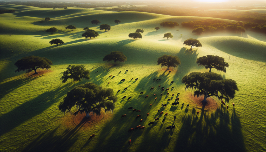
If you run cattle in Florida, you know the land speaks to you. Brown patches, uneven growth, areas the herd avoids — these are all signs. But walking a 200-acre pasture on foot only shows you part of the picture. From 400 feet up, a drone shows you the whole thing.
At Precision Aerial Services, we help Florida ranchers see their grazing land the way God intended — clearly, completely, and in time to do something about it.
What Drone Surveys Reveal About Pasture Health
A single aerial survey can identify issues that take weeks to notice from the ground:
- Overgrazing zones — Areas where forage is depleted faster than it recovers, visible as thinning or bare patches from above
- Underutilized sections — Parts of the pasture the herd consistently avoids, often due to poor drainage, shade patterns, or old fence lines
- Weed encroachment — Invasive species like tropical soda apple or cogongrass show distinct color and texture patterns in aerial imagery
- Water drainage issues — Standing water and poor drainage paths that create mud zones and reduce usable acreage
- Fence line integrity — Gaps, leans, and damage visible across miles of perimeter in minutes
Smarter Rotational Grazing Starts With Better Data
Most ranchers rotate cattle based on time — move them every two weeks, follow the same pattern, hope for the best. But Florida’s weather doesn’t follow a calendar. A wet February changes everything compared to a dry one.
Drone imagery lets you rotate based on actual forage condition, not guesswork. When you can see which paddocks have recovered and which haven’t, you make better decisions. Your grass stays healthier. Your soil stays covered. Your cattle gain weight more consistently.
That’s not fancy technology for technology’s sake. That’s just good stewardship of the land you’ve been given.
Florida-Specific Challenges We See From the Air
Florida pasture management is different from anywhere else in the country. Our subtropical climate creates unique challenges:
- Summer flooding patterns — Afternoon storms can waterlog sections of pasture for days, and drone surveys show exactly which areas drain well and which don’t
- Bahiagrass and bermudagrass health — The dominant Florida forages respond differently to stress, and aerial imagery catches decline before it’s obvious at ground level
- Armyworm and mole cricket damage — Pest damage creates distinctive patterns visible from above, allowing targeted treatment instead of blanket applications
- Nutrient runoff concerns — With Florida’s water table and proximity to waterways, precise application matters more here than almost anywhere
Part 137: Why the License Matters for Your Ranch
Precision Aerial Services holds a Part 137 agricultural aircraft operator certificate from the FAA. That’s the same certification required for manned crop dusters, applied to drone operations.
For pasture management, this means we can legally apply fertilizers, herbicides, and soil amendments aerially — targeting only the areas that need treatment based on survey data. No driving heavy equipment across wet pasture. No soil compaction. No tearing up ground that’s trying to recover.
What a Typical Pasture Survey Looks Like
Here’s what to expect when you work with us:
- Pre-flight consultation — We talk about what you’re seeing on the ground and what you want to know
- Aerial survey — Typically 30-60 minutes of flight time for most ranches, covering hundreds of acres
- Data processing — We generate high-resolution maps showing vegetation health, problem areas, and recommended actions
- Actionable report — Plain-language findings you can act on immediately, not a stack of technical data you need a PhD to read
Most ranchers tell us the first survey pays for itself by catching one problem they would have missed for another month.
Good Stewardship, Better Tools
Ranching in Florida has always been about working with the land, not against it. Drones don’t change that philosophy — they just give you better eyes to do it with. When you can see the whole picture, you make better decisions. Better decisions mean healthier pastures, healthier cattle, and a ranch that’s still productive for the next generation.
If you’re managing grazing land in Central Florida, we’d love to show you what your pasture looks like from above. Give us a call and let’s talk about your operation.
Hugh MacDonald
Precision Aerial Services
Dover, Florida
pasuav.com